
Interested in advertising on Derpibooru? Click here for information!

Help fund the $15 daily operational cost of Derpibooru - support us financially!
Description
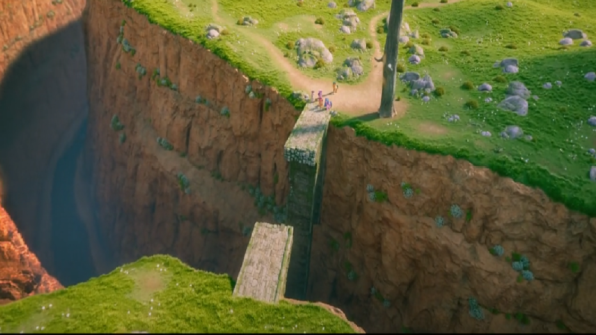
You shall not pass!
Okay seriously where in Equestria are they? Was Zephyr Heights really Canterlot, or was it just a base in Equestria that became the Pegasai’s capital? And this bridge, when was that built? This can’t be the same forest that the Treehouse of Friendship was in..so many questions..
Okay seriously where in Equestria are they? Was Zephyr Heights really Canterlot, or was it just a base in Equestria that became the Pegasai’s capital? And this bridge, when was that built? This can’t be the same forest that the Treehouse of Friendship was in..so many questions..
Source
not provided yet
How about the animals that live in the forst? Fluttershy would be so sad
The movie showed that there is nothing around the harmony tree that stood where the castle of the royal sisters had stood, and this was originally located on a hilltop that can be seen on the movie. From there you could look down on Ponyville in the northwest and Canterlot in the southeast, from the angle of the camera we only see to the northwest, west and southwest to the south - the angle of the mountain with Zephyr Heights was deliberately kept away. We never saw the lowest parts of the valley where Ponyville and the rivers are located when the G4 was running. There were no signs of overgrowth despite the fact that there was a very densely planted forest there that has meltwater available from the surrounding mountains.
As there was a period of time between the area around the harmony tree and the ravine with the stone bridge (two bridges were seen in the G4, when these crossed the ravine), it was believed that Sunny had gone up the slopes towards the mountains which served as the background for the castle in the G4, where the ravine also went. All the while they were on a higher slope in the eastern part of the valley where Everfree had once stood. On the pre-S8 map from the lighthouse, it can be seen that there is a road down Rambling Rock Ridge that seems to end in the northeastern part of the forests. Since Argyle may have gone there and made the map that Sunny copied for her own use, it meant that he had come to Rambling Rock Ridge or the foot of it, and thus could easily enter the forest - if it was there. Instead, Sunny came out in an empty area with meadows everywhere and only a solitary tree. Argyle marked the tree as a landmark, as from there one could follow the ravine towards the stone bridge which seemed to have collapsed in the time between Argyle`s visit and Sunnys arrival.
But Sunny mentioned “the river”. We know there are several river courses in the valley, so it may be Ghastly Gorge that was clearly visible on the pre-S8 valley, it continues in a southwesterly direction. The official Hasbro map is useless, but on the road between Rambling Rock Ridge and Dodge City there is a smaller bridge not far from large rock formations. When the Mane 5 took over, they had very high mountains to the left and in front of them. The map shows that there are snow-capped mountains (nameless, unfortunately) to the east, which we may have seen from the other side when Sunny and Izzy went out to Zephyr Heights. In front of them, they will thus have the northeastern part of the Macintosh Hills, which may be where Bridlewood is located on a flat plateau. (The entire area around Dodge City and Appleloosa could be moved west of Canterlot if Hasbro releases a much larger scale map)
From there we can have descending slopes and slopes towards the east coast, making it possible for the lantern from Maretime Bay to get there. The Mane 5 spent the night in the Macintosh Hills to get through the valleys up in the terrain. There is obviously a passable road there that may have crossed the river with a bridge or pedestrian crossing, which a vehicle can use, between Bridlewood and Maretime Bay. Izzy will not have much difficulty following this road which strangely enough ended up on the slopes towards the lighthouse, maybe Baltimare was not accessible due to divine intervention (writers). Sprout had to drive up and past the lighthouse to get deeper into the country.
This means that the bridge is southeast or southwest of the harmony tree, from there you could go up into the Macintosh Hills (I think it is a little visible ruin on one of the mountains) and on towards Bridlewood. Because if they were going to White Tail Woods, they would have to get through Ponyville and would not come across the harmony tree, as there are possibly shallower rivers there that they can cross. A lantern can not get that far up with onshore winds if there are large mountains on the road, there must be advantageous terrain that allows deep penetration for wind from the sea as low-flying things as lanterns can appear.
We can just as well see that the official map from Hasbro is so hopeless, that even Hasbro will not use it. The scale is simply too bad, extremely childishly designed and violently grossly simplistic. But at least we know that Zephyr Heights is at least a day and a night away, even though it has been seen that they could cut off parts of the journeys.
At 30 km / h - Sunny and Izzy are seen galloping - they can reach 1,000 km in 33 hours. It took all day between Zephyr Heights and Mcintosh Hills, and they were at a slower speed down to 15 km / h, so it meant about 150 to 180 km. We can thus calculate a radius of 800 to 1,000 km. There is much to suggest that Canterlot is much closer to the east coast than the west coast, as it appears that Equestria may be 3,000 km or more between the west and east coasts. Under normal circumstances, it would take three days to get to Zephyr Heights, but the writers did not care. Instead, the whole action in the movie happened during this time.
At the very least, it is clear that Bridlewood is not located in the valley itself, as the Mane 5 had to go up in the surrounding mountains that surrounded the G4 valley. And since Bridlewood is closer to Maretime Bay, that means it is far to the south. But then it means that it is located in the Macintosh Hills themselves, most likely in the northeastern part.
or like how empire of china become the CCP
Bridlewood was Hollow Shades
Maretime Bay was Horseshoe Bay
Zephyr Heights was Rainbow Falls
In this case they would be treading a path along the coast that there would have been train tracks… but I guess those are long gone, who knows. All our map guesses are plausibly wrong because the show can do whatever it wants..
Edited
Or it ended up becoming like Istanbul. A new empire(Griffons or Dragons) took it over, and have ruled it for so long that everyone agrees, its Turkish now not Greek. It’s not Constantinople anymore, its Istanbul.
Dragon Soldier: Canterlot is gone. Its Draconia now.
That’s the map I’m working from as well.
given roman history where they found out that the hill was in fact 7 cities build on top of each other of each ruins
Which means we might see Canterlot’s ruins in the series, or maybe its under new creature authority?
heres a map
https://derpicdn.net/img/2021/8/12/2676332/large.png
Unless the deforested the place.
Everfree Forest getting cleared out…is a good thing, that forest was savage